Can You Read Me Now? New Private Cellular Tower Prototype Helps Field Researchers Connect Remote Sensors
By Bonnie Powell, media@es.net
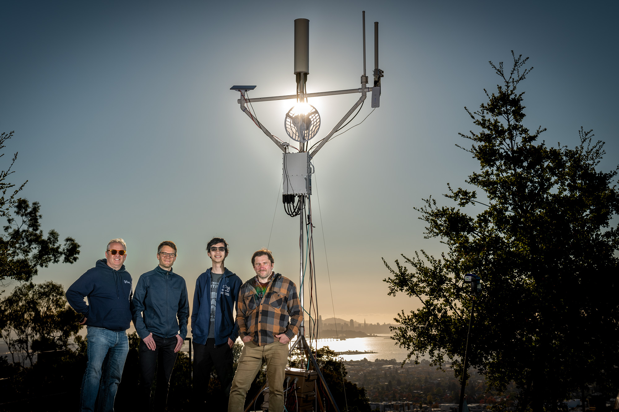
Left to right: Andrew Wiedlea (ESnet), Stijn Wielandt (Earth and Environmental Sciences Area), Howard Yao (EESA), and James Kafader (ESnet) in front of the Greenfield Wireless Edge Site Characterization tower during the November test at Berkeley Lab.
As sensors, drones, field bioassays, and other portable scientific devices become more mobile and less expensive, scientists have deployed countless thousands of these small devices outside the lab. In remote “greenfield” sites all over the United States, they are recording data on groundwater, soil emissions, tremors, snowpack temperatures, cloud formation, and many other Earth system features.
However, what makes the locations for these deployments ideal for experiments also makes them challenging for researchers to retrieve the important data being collected. For example, there’s no Wi-Fi in mountain meadows and desert valleys, and often there is poor or no commercial cellular service. This important research infrastructure thus relies on various alternate “data backhaul” methods. Many researchers are not equipped to set up a sophisticated data-transmission system: quite a few still depend on an old-fashioned “sneaker net” — visiting their devices regularly to swap out memory sticks or hard drives.
A team of networking experts and field scientists at Lawrence Berkeley National Laboratory (Berkeley Lab) has developed a novel prototype for an affordable, flexible private cellular system that will dramatically simplify connectivity for sensor sites in these remote, resource-constrained locations. The Greenfield Wireless Edge Site Characterization project is co-led by Andrew Wiedlea, a computer systems engineer for the Energy Sciences Network (ESnet), a DOE Office of Science User Facility stewarded by Berkeley Lab, and Stijn Wielandt, a research scientist in Berkeley Lab’s Earth and Environmental Sciences Area (EESA). For the project, Wiedlea leads networking development, and Wielandt adapts the ever-evolving prototype to various science use cases. (Wielandt obtained a Ph.D. in electrical engineering through his wireless research and has considerable mechanical engineering skills.) The two have been collaborating with other staff at ESnet and EESA as well as with scientists from Argonne National Laboratory, the National Renewable Energy Laboratory (NREL), the University of Nevada-Reno, and Cal Poly San Luis Obispo.
After two years of development and experimentation in the field, the Greenfield Wireless team has built an affordable prototype that can be easily transported and quickly set up to assess what a field research site requires in the way of connectivity. In late 2024, they successfully field-tested the prototype first at Berkeley Lab, then at an Ameriflux soil-emissions-testing site in California’s Sacramento Delta and at two geothermal sites in Utah and Nevada.
A Watershed Moment for Wireless
ESnet is known as the Department of Energy’s (DOE’s) “data circulatory system,” connecting the DOE scientific research ecosystem via a blazingly fast, high-performance optical network. ESnet’s vision is that “scientific progress will be completely unconstrained by the physical location of instruments, people, computational resources, or data.” To better support the data needs of field researchers, ESnet has developed a multifaceted Wireless Edge program, also led by Wiedlea, of which the Greenfield Wireless system is but one element. (ESnet’s other major wireless focus is an interoperable, on-campus private cellular system initially being developed for Berkeley Lab, Argonne National Laboratory, and NREL, but open to any other national labs that wish to participate.)

ESnet’s first prototype of a private cellular tower for transmitting scientific field research, located on Crested Butte Mountain in Colorado
“We’re focused both on reducing the costs and uncertainty associated with sensor deployments, and on making it easier for researchers to retrieve these important data and keep them available to the DOE ecosystem,” says Wiedlea. “For ESnet, it’s about extending our expertise in fiber-optic networking hardware — and in co-designing custom networking solutions for DOE-funded scientists — to create a set of mobile wireless resources that we can easily deploy to field sites or utilize at the national labs.”
According to Wielandt, this collaboration with ESnet allows EESA scientists not only to get access to reliable and robust communications infrastructure, but the real-time communications capabilities also create opportunities for effective sensor management and even new science use cases. “For example,” he explains, “at one of our field sites, ESnet’s infrastructure allowed us to stream large amounts of unprocessed radar data to Berkeley Lab, allowing our servers to take action and control these systems in real time. This type of self-driving field laboratory is a game changer for environmental sciences.”
Portable Tower Passes Test with Flying Data
The Greenfield Wireless team first built and deployed the initial prototype of the private cellular system in 2022 on Colorado’s Crested Butte Mountain. The first installation used private 4G Citizens Broadband Radio Service (CBRS) hardware to connect sensors from the Surface Atmosphere Integrated Field Laboratory (SAIL), campaign, which was supported by part of the Atmospheric Radiation Measurement (ARM) User Facility, but was located at Crested Butte, along with Berkeley Lab’s Watershed Function Science Focus Area program. In 2023, the team returned to Crested Butte and constructed a research 5G tower designed to support multiple wireless technologies (5G CBRS, satellite broadband, LoRa, Wi-Fi, Wi-Fi HaLow, millimeter wave, and proprietary radio protocols for environmental sensors) and successfully connected it to several sensor sites belonging to the Watershed Function SFA project.
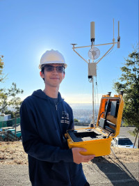
Yao holds the mobile test unit he designed, which enables the team to produce multi-technology wireless coverage maps quickly on site.
The fixed tower in Colorado taught the team a lot about what a portable, self-powered testing system would need. In mid-November 2024, Wiedlea, Wielandt, James Kafader (ESnet), and Howard Yao (EESA) conducted the first operational trial deployment of a new Greenfield Wireless Edge Site Characterization system on-site at Berkeley Lab. The new unit is 4 meters tall and weighs approximately 200 pounds; it is designed to be broken down and transported in several manageable cases. On the crossbar are mounted a Starlink Mini terminal that is used to backhaul data from the system to ESnet’s fiber network (available through peering arrangements in multiple U.S. locations); a multi-sector cellular antenna; an omnidirectional Wi-Fi HaLow antenna for long-range, low-bandwidth connections; and an omnidirectional 5 GHz antenna for long-range, high-bandwidth, point-to-multipoint links. Below that is a square box containing a 4G private cellular CBRS radio unit. The system is designed to run on batteries for at least 10 hours, but an integrated solar inverter can provide 24/7 operations.
The multi-format-wireless, self-powered approach was designed to allow the Greenfield Wireless team to quickly assess and characterize a site’s needs. The system includes a mobile test unit designed and built by Yao, who joined Wielandt’s team initially in August 2024 as an intern through Berkeley Lab’s Community College Internship program and now works for EESA as a student assistant. The portable testing unit features a ruggedized enclosure with battery packs, a GPS receiver, and antennas for multiple wireless networking technologies. Yao has programmed an integrated field computer to measure all wireless signal parameters every 10 seconds and link them to a GPS location, producing multi-technology wireless coverage maps.
Field research sites differ in size, terrain, availability of power, data transfer needs, and other essential characteristics, and “modeling only gets you so far,” says Wiedlea. “Our system lets us identify the best technology for a site in a single measurement activity.”
For the trial deployment at Berkeley Lab, the team was able to unpack, assemble, operate, and test the tower and its components, then tear it down and pack everything back up in under five hours. Most importantly, they were successfully able to transmit data from the tower over private cellular service to phones 3.5 miles away at the Berkeley Marina. The Greenfield Wireless team was ready to hit the road in a rented truck for actual field tests.
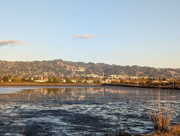
View from the Berkeley Marina back to the Greenfield Wireless tower erected temporarily in late November at Berkeley Lab, in the Berkeley hills.
Connecting Sensors Measuring Soil Emissions and Seismic Data
In late November 2024, the team drove to Staten Island, just across the South Mokelumne River in California’s Sacramento Delta area, to assess the wireless connectivity options at a site that is part of the DOE’s AmeriFlux program. This site has all kinds of sensors, including ones that monitor emissions from anaerobic soil bacteria in a corn field.
Next, in early December 2024, they headed to an arid plain 15 miles from Milford, Utah. In partnership with Fervo Energy, a developer, owner, and operator of geothermal assets, researchers from Berkeley Lab, NREL, and Idaho National Laboratory are collecting seismic data for geothermal energy production at multiple pads. Most of the sites are solar powered, with very limited electricity and low data-production rates, except for three fiber-optic Distributed Acoustic Sensor (DAS) instrumented wells, which will increase data movement needs. The team determined that Wi-Fi HaLow and/or directional radio links appear to be the most reliable and cost efficient choice for this site, versus CBRS LTE.
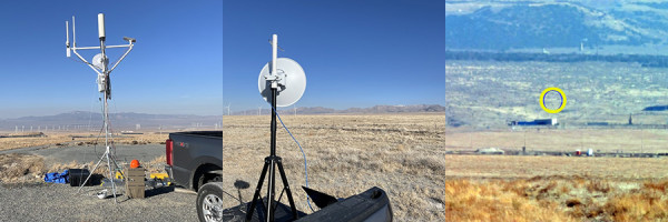
The test tower set up on a sensor pad at the Fervo site, the Wi-Fi HaLow unit set up at the site’s westernmost pad, and a 30x magnified view of the test tower from the HaLow unit’s location.
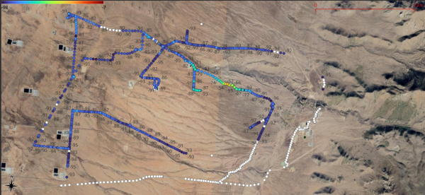
Resulting coverage map of the Fervo Utah site, showing Wi-Fi HaLow signal strength at each dot in the database
A few days later, Wiedlea and Wielandt drove to the Ormat Geothermal Plant in Jersey Valley, Nevada, where they were joined by colleagues from the University of Nevada Reno’s Seismic Lab. This new field site for Berkeley Lab researchers is located on an unpaved road, with topographically challenging terrain and frequent fog. Pads for scientific instruments were in the process of being installed; sensors that will collect 10 gigabytes of seismic data per day are scheduled to be deployed in late January 2025. The team conducted an extensive driving tour of the area, taking multiple connectivity measurements at each pad. They determined that a private cellular system combining Wi-Fi HaLow and point-to-multipoint radiolinks would best serve this challenging geothermal field site, which they hope to install in February or March 2025. First they must evaluate adding a load-balancing router, sort out power logistics, set up a 24/7 Starlink backhaul, and address other site-specific challenges.
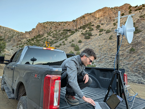
Wielandt connects to the directional radiolink unit for a test at the Ormat site.
Scientists working at the Utah and the Nevada sites agree that increased data backhaul capacity would be transformative. "One of our most significant challenges at the moment is effectively processing the hundreds of terabytes of DAS data we acquire annually at the Milford site,” explains Jonathan Ajo-Franklin, Rice University Professor of Earth, Environmental, and Planetary Sciences and a visiting faculty scientist at Berkeley Lab, who is working on multiple projects for the DOE’s Office of Geothermal Technologies. “While we are experimenting with edge-processing solutions, obtaining the best real-time interpretation of our seismic data requires the bandwidth to move our full datasets back to offsite HPC resources. If this were possible, a whole new world of induced seismicity analysis algorithms could be applied to this massive data stream."
Designing a Public Blueprint for Private Cellular Networking
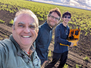
Wiedlea, Wielandt, and Yao enjoy their field trips
Alas, Wiedlea and Wielandt can’t personally road-trip to the thousands of sensor sites all over the United States — although they’d probably love to try.
The Greenfield Wireless team’s ultimate goal is to document exactly what they’re doing and how they’re doing it, using off-the-shelf components and field-tested methods, creating a blueprint that any researcher can follow. Then, tech-savvy teams at other national labs can start assessing sites and installing similar towers at their federally funded research sites. ESnet staff would be available to support these efforts to improve field science connectivity in the same way that the organization supports other science community best-practice protocols such as networking’s Science DMZ.
For now, however, the Greenfield Wireless Edge Site Characterization tower is a flag planted in the field, beaming toward a future in which researchers can much more easily monitor their remote data-collection devices, see their results in real time, and potentially adjust their experiments on the fly.
If you’re interested in partnering with the Greenfield Wireless team or learning more, email engage@es.net.